
01Setting and coastal landscape
The southern Adriatic, the municipal area and the Mediterranean climate.
Setting and coastal landscape
The southern Adriatic, the municipal area and the Mediterranean climate.
On the southern Adriatic
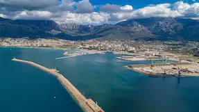
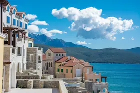
Ulcinj lies in the southern part of Montenegro's coast. The wider municipality includes the coastal plain and the area along the Bojana River, while Lake Shas lies in its central part. The hinterland extends toward the Rumija massif.
The Ulcinj area has an Adriatic form of the Mediterranean climate, with hot summers. The summer maestral wind blows from the west and southwest, bringing air in from the sea. The bura is a cold northeasterly wind in late fall and winter, while the jugo brings rain and waves in fall, winter and spring.
02The historic town and its changing economy
The fortified center, maritime connections and the growth of the tourist area.
The historic town and its changing economy
The fortified center, maritime connections and the growth of the tourist area.
The Old Town under successive rulers
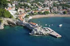
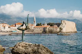
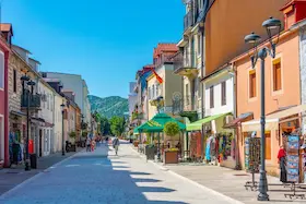
The Old Town occupies a rocky rise beside the sea. Walls and gates enclose a densely built center of narrow, winding streets and stone houses. The citadel with Balsic Tower stands on the upper plateau, while Renaissance, Baroque and Ottoman elements reveal different phases of construction.
Venetian rule strengthened the town's fortifications and left its mark on the walls and defensive buildings. The Ottomans conquered Ulcinj in 1571. Balsic Tower was extended upward during the Ottoman period.
A maritime and trading past
Ulcinj's seafaring connected the town with other Adriatic coasts and the wider Mediterranean. During the Ottoman period, shipping, trade and shipbuilding were important parts of its economy.
Piracy developed alongside trade. Captives were brought to Ulcinj to be sold or ransomed, and the name Slave Square (Trg robova) preserves a trace of that past in the Old Town.
From maritime town to tourism center
Ulcinj became part of Montenegro in 1880. Its former maritime and trading role declined in the period that followed. The economy later diversified with the Salina saltworks and hotel construction, particularly between the two world wars.
Postwar hotel development extended across both the town and Velika Plaza. Tourism spread beyond the central area toward the sandy coast and the settlements on the Stoj plain. This development explains why Ulcinj as a modern tourist destination covers much more than the fortified center and the town's bay.
03Museum heritage and cultural life
Museum collections, historic buildings and Ulcinj's cultural programs.
Museum heritage and cultural life
Museum collections, historic buildings and Ulcinj's cultural programs.
Museum heritage in the Old Town
Ulcinj Local History Museum is part of Ulcinj Cultural Center and is located in the Old Town. Its archaeological collection is housed in a building that was originally a church and later a mosque. Its present use as a museum is the latest in this sequence of different uses of the same building.
The museum's collections include archaeological, ethnographic and artistic material. Older finds include stone inscriptions and architectural fragments from antiquity and the medieval period. Balsic Tower is used as a gallery and a venue for poetry evenings.
Ulcinj's cultural scene
The Cultural Center organizes the Summer Scene festival (Ljetnja scena), whose program includes music, theater, exhibitions and literature. Slave Square in front of Balsic Tower is among its venues, so this part of the Old Town also hosts public cultural events today.
The Ulcinj Book Fair brings together authors and publishers from Montenegro and abroad. You can find specific dates and venues for cultural programs in announcements from the Ulcinj Tourist Organization.
04Olive groves and wetland landscapes
Valdanos and the Salina as areas shaped by economic activity and nature.
Olive groves and wetland landscapes
Valdanos and the Salina as areas shaped by economic activity and nature.
Olive groves and Valdanos Bay
Valdanos Bay is surrounded by olive groves. Groves of old trees stretch between the town and the bay, and olives are still grown in this area today.
The Salina and wetlands along the Bojana
Ulcinj Salina was created by developing a wetland area for salt production. Its pans, channels and embankments remain part of the industrial heritage of the wider Bojana delta.
The shallow pans and wetland habitats are important for birds feeding, nesting and wintering, as well as for their stopovers on the Adriatic migration route. The Salina has been designated a nature park and included on the Ramsar List of Wetlands of International Importance.
05A brief overview of Ulcinj's areas
The town's coast and the Velika Plaza plain, with guides to attractions, food and accommodation.
A brief overview of Ulcinj's areas
The town's coast and the Velika Plaza plain, with guides to attractions, food and accommodation.
A brief overview of Ulcinj's areas
The Old Town walls, the Valdanos olive groves and the Salina's pans represent urban, agricultural and industrial heritage in different parts of Ulcinj municipality. The guide to Ulcinj attractions covers individual buildings and natural sites in more detail.
Pristan and Mala Plaza are on the town's coast below the walls, while Velika Plaza extends from Port Milena toward the Bojana River, alongside the Stoj plain. For specific choices in these areas, continue with the guides to where to eat in Ulcinj and where to stay in Ulcinj.
The town, the plain and the wider surroundings
A fortified rise beside the sea, with the town's Mala Plaza cove and the coast below the walls.
The coastal area from Port Milena toward the Bojana River, with settlements on the plain behind the beach.
The olive-growing area around Valdanos Bay and the separate wetland area of the former salt pans.