
01Rivers and climate
The Moraca separates the larger districts, the Ribnica divides the old and newer quarters, and the climate brings hot summers and rainy winters.
Rivers and climate
The Moraca separates the larger districts, the Ribnica divides the old and newer quarters, and the climate brings hot summers and rainy winters.
The Moraca, Ribnica and rivers of the surrounding area
The Moraca flows through the city from north to south in a channel cut between rocky banks. In many places the water is well below street level, so the city bridges offer views of both the river and the high stone sides of its channel. The bridges connect the older districts on the left, eastern bank with the large postwar neighborhoods on the right, western bank.
The Ribnica flows from east to west along the northern edge of Stara Varos, the old quarter. Across its channel begins Nova Varos, now the city center. At Sastavci, where the Ribnica joins the Moraca, the riverbanks and old stone bridge lie below the surrounding streets.
The Moraca continues toward Lake Skadar. The Cijevna River runs through the eastern and southern parts of the wider lowland area, outside the city center.
Long, hot summers and rainy winters
Podgorica has a modified Mediterranean climate. The Adriatic influences it through the Bojana valley and Lake Skadar, while the surrounding mountains alter conditions in the basin. Summers are long, hot and mostly dry. Open squares and boulevards feel hotter than the shade beneath trees in the city parks. Mornings and evenings are the more comfortable parts of a summer day.
Winter is milder than in Montenegro's mountains, but often rainy. Strong northerly winds can bring cold days even in this lowland city. Spring and autumn have more moderate temperatures, so spending longer outdoors is less dependent on choosing the early morning or evening.
02History and the city's names
Wartime destruction and the rebuilding of Titograd explain why postwar construction dominates Podgorica today.
History and the city's names
Wartime destruction and the rebuilding of Titograd explain why postwar construction dominates Podgorica today.
Duklja and settlement in antiquity
Settlements around Podgorica are older than the medieval records of its name. In Roman times an important urban center here was Doclea, known today as Duklja, north of the modern center where the Zeta meets the Moraca. It was a planned town, with a regular street grid and a public square surrounded by important civic buildings. In the later Roman period it became one of the significant centers of the province of Prevalis.
Duklja was destroyed and abandoned during late antiquity and the early Middle Ages. The medieval settlement of Ribnica emerged farther south, beside today's Ribnica River and closer to its confluence with the Moraca. The oldest parts of modern Podgorica occupy that area. Duklja was a separate ancient settlement, rather than an earlier name for the same urban core.
Ribnica, the name Podgorica and the Ottoman town
Medieval documents mention a settlement called Ribnica in the area of the future Podgorica. Both names, Ribnica and Podgorica, were in use during the early decades of the 14th century. The earliest known written mention of the name comes from a court document in the Kotor archives dated 1326. The settlement already existed, so the document does not give the year the city was founded. Its name describes its position beneath Gorica hill.
Podgorica came under Ottoman rule in 1474. Depedogen Fortress was built where the Ribnica meets the Moraca, and residential lanes, trade, crafts and mosques grew around it. Its position at a road junction gave the town both military and commercial importance. Surviving houses, lanes and religious buildings from that period are now in Stara Varos, south of the Ribnica.
From an expanding town to Titograd and the capital
The Congress of Berlin decided in 1878 that Podgorica would become part of Montenegro. The actual handover followed in 1879. The town then expanded north of the Ribnica, beyond the Ottoman core. Planned construction of Nova Varos began in 1886, introducing a regular street grid, a square, shops and public services. Trade and crafts continued to grow as new schools and institutions opened.
Bombing during World War II severely damaged Podgorica. In 1946 it was renamed Titograd after Josip Broz Tito and became the capital of the then Republic of Montenegro. Reconstruction also brought major expansion. Government buildings, schools and housing were built as the city took on new administrative and economic responsibilities. Construction spread to the right bank of the Moraca, with boulevards and large apartment blocks. The wartime losses and extensive postwar building explain why fewer old buildings survive than might be expected in a settlement with such a long history.
The name Podgorica was restored on April 2, 1992. Montenegro regained its independence in 2006, when Podgorica became the capital of the independent state. Districts built during the Titograd period remain a substantial part of the city, alongside older quarters whose street patterns differ from those of the postwar neighborhoods.
03Neighborhoods and the city today
Courtyard walls screen homes in Stara Varos, shops face the streets in Nova Varos, and Preko Morace has open spaces and greenery between apartment buildings.
Neighborhoods and the city today
Courtyard walls screen homes in Stara Varos, shops face the streets in Nova Varos, and Preko Morace has open spaces and greenery between apartment buildings.
Stara Varos, the old quarter
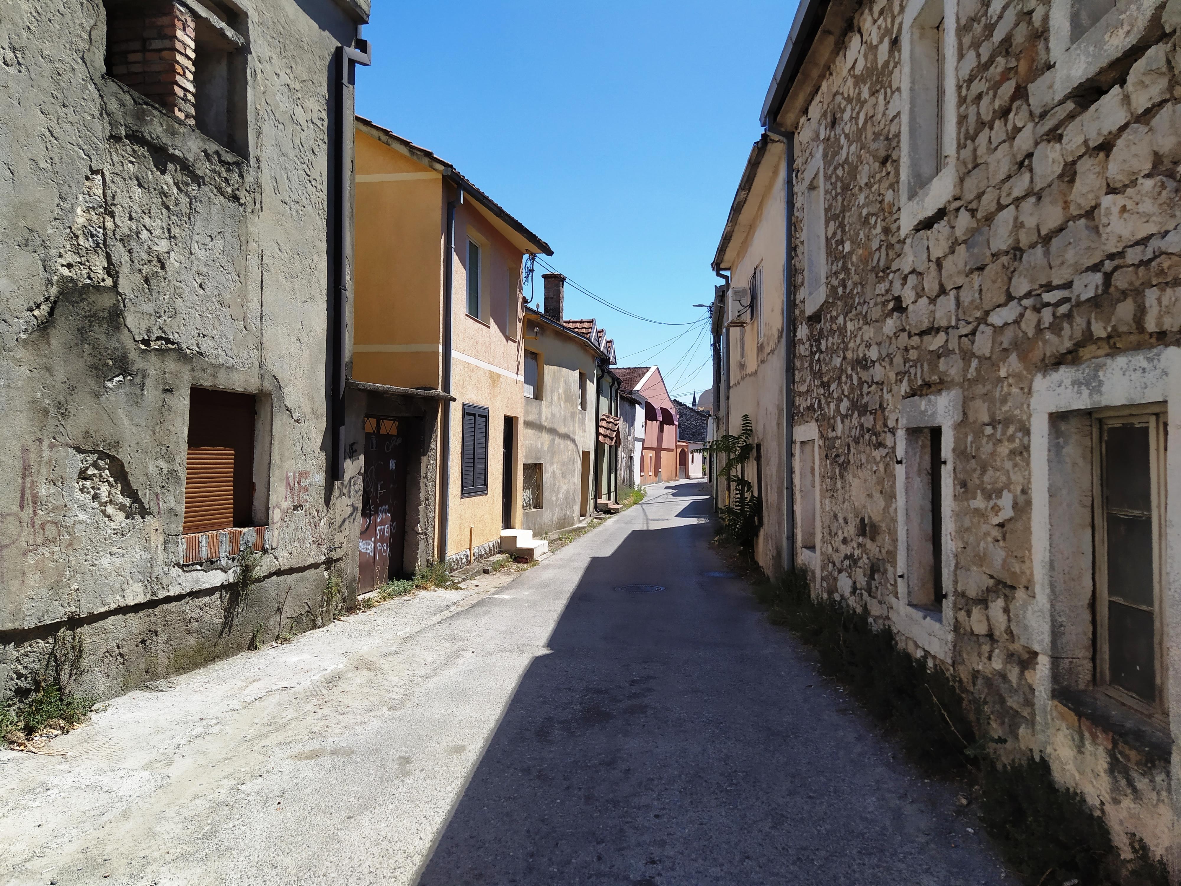
Stara Varos is a residential neighborhood south of the Ribnica, on the left bank of the Moraca. Lanes pass between low houses and the stone walls of avlije, courtyards screened from the street. The streets are narrow and irregular, with some dead ends. This layout developed within mahale, the small neighborhoods of the Ottoman town. Newer construction now stands among the older houses, so this is not a completely preserved historic core.
Nova Varos, the newer town center
Nova Varos lies north of the Ribnica. Historical texts also call it Mirkova Varos. It developed through planned construction after Podgorica became part of Montenegro, with straighter, wider streets than those in the old quarter. Today it is the city center, around Independence Square and Slobode Street, with Bokeska and Njegoseva nearby. Shops, restaurants and cafes open onto the streets, unlike the more enclosed courtyards of Stara Varos.
In Nova Varos, older traces of the city often survive in the line of a street rather than the building you are looking at. Many houses were replaced after the wartime destruction, while some street alignments remained from the earlier plan. Today's center therefore combines an older street layout with many newer buildings.
Preko Morace and postwar expansion
Preko Morace, meaning across the Moraca, is the collective name for the wider area on the river's right, western bank. Postwar construction occupied a much larger area here than the earlier town. Apartment buildings stand in blocks, with open spaces and greenery between them, alongside broad boulevards. Rimski trg, the university buildings and the cathedral are in this part of the city. Preko Morace therefore includes several neighborhoods and public spaces, rather than a single street or square.
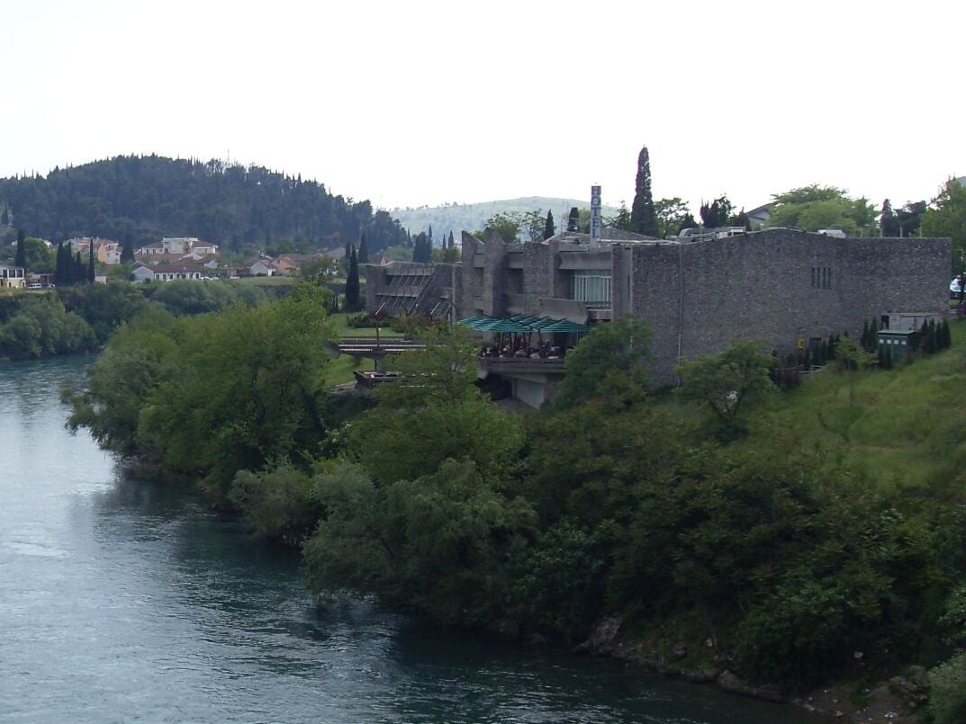
Beside the Moraca, opposite Stara Varos, stands Hotel Podgorica, built in 1967 to a design by Svetlana Kana Radevic. Its terraces sit lower down toward the river, while the elongated wing containing the rooms and main entrance is at street level. River pebbles on the facade distinguish it from the surrounding apartment buildings.
04Podgorica today
The Government, Parliament and University are based here, while local food and wine have links to the Zeta Plain and Lake Skadar.
Podgorica today
The Government, Parliament and University are based here, while local food and wine have links to the Zeta Plain and Lake Skadar.
An administrative and university center
Montenegro's Government and Parliament have their headquarters in central Podgorica. Other state institutions and diplomatic missions are also based in the city. Podgorica serves as the national capital, while Cetinje retains the official status of Prijestonica, the Old Royal Capital. The University of Montenegro, founded in 1974, is also headquartered in Podgorica. Its rectorate and technical faculties share a campus in Preko Morace, on the western side of the river.
Theater, museums and cultural life
The Montenegrin National Theatre in the city center has a professional ensemble. Its drama repertoire includes Montenegrin and foreign playwrights, with performances on the Main Stage and Studio Stage.
The City Museum on Marka Miljanova Street holds archaeological, historical and ethnographic material, ranging from finds from earlier settlements to documents, photographs and objects relating to later city life. The Museum of Contemporary Art of Montenegro holds a collection assembled through cultural cooperation among non-aligned countries, including works by artists from Africa, Asia and Latin America. The collection developed in Titograd, linking the city's history with international artistic exchange.
Contemporary art exhibitions take place in several venues, including the Petrovic Palace in Krusevac and the gallery in the former Lexicographic Institute in the center. The former institute building is another work by Svetlana Kana Radevic, with large areas of glazing.
Food and wine from the plain and lake region
Podgorica is close to the vegetable-growing villages of the Zeta Plain and the fishing settlements of Lake Skadar. Produce from the plain and fish from the lake therefore belong to the local cuisine. Krap, or carp, and small ukljeva, a type of bleak, come from the lake south of the city.
The extensive Plantaze vineyards cover Cemovsko polje southeast of the city. They were established by preparing rocky land and planting vines as part of a project carried out between 1977 and 1982. The varieties include Vranac, used for red wine, and Krstac, a white grape.
05A short overview of Podgorica's sights
The Clock Tower and old Ribnica bridge are in the city, while Duklja, Medun and the Sipcanik wine cellar require a trip beyond the center.
A short overview of Podgorica's sights
The Clock Tower and old Ribnica bridge are in the city, while Duklja, Medun and the Sipcanik wine cellar require a trip beyond the center.
Stara Varos and the Ribnica confluence
The Clock Tower and mosques of Stara Varos are notable reminders of the city's Ottoman past. Nearby are Sastavci, the old stone bridge over the Ribnica and the fortress remains, on lower ground beside the confluence.
Architecture and Gorica within the city
Modern architecture includes the Millennium Bridge and the Cathedral of the Resurrection of Christ, a large Orthodox church in Preko Morace. Gorica hill has woodland paths and the Partisan Fighter monument, with St. George's Church at its foot.
Archaeology, a monastery and wine outside the center
Places beyond the center include the archaeological site of Duklja and Medun with the Marko Miljanov Museum in Kuci. South of the city is the cave church at Dajbabe Monastery. Toward Tuzi are the waterfall on the Cijevna and the Sipcanik wine cellar. Visiting conditions and seasonal differences are covered with each sight.
Where Stara Varos, the center and Preko Morace lie
South of the Ribnica and east of the Moraca.
In Nova Varos, north of the Ribnica and east of the Moraca.
On the western bank of the Moraca.