
Hire And Travel
  • List your vehicles
  • Home
  1. Home
  2. Montenegro
  3. Ulcinj
  4. Guide
  5. Drives and day trips
  6. Šas, Lake Šas and Štegvaš: a drive from Ulcinj
logo
Home
About us
Terms of use
Privacy policy
List your vehicles
Become our partner
Contact us
FAQ - Questions and answers
Brands We Trust
Hire And Travel - 2026. All rights reserved.
DRIVING DAY TRIP FROM ULCINJ

Šas, Lake Šas and Štegvaš: a drive from Ulcinj

Above Lake Šas stand the walls of a town that minted its own coins in the Middle Ages. Its ruined churches mark a former episcopal centre, with the lake below the ridge. This drive through the Ulcinj hinterland combines a visit to the ruins with a lakeside lunch and Štegvaš, a mountain pass overlooking the much larger Lake Skadar.
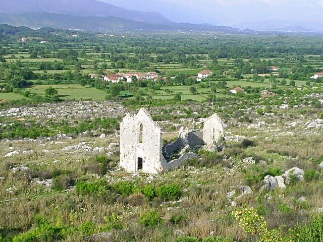
Church ruins at Šas in the countryside near Ulcinj

Trip overview

Trip duration
7-8 hours
Places and breaks
3
Route length
About 73 km
AuthorHire And Travel Editorial TeamLast updated18 October 2026

The guide was prepared through research into the route and the attractions visited. Editorial responsibility: Takumi Bulatovic.

Why set aside a day for this trip

Šas offers a part of Ulcinj you will not discover on a walk along the seafront. The former town survives as ruins, so you explore its setting, walls and churches by following paths between the remains. It is a day suited to an interest in archaeology, photography and time outdoors.

These inland stops do not require a long journey along the coast. Short drives through villages leave time to explore and take an extended break beside the lake. Štegvaš adds a view across Lake Skadar towards the Albanian mountains. Reaching the pass is enough to enjoy that panorama, without continuing along the slow lakeside road to Virpazar.

Trip and costs at a glance

Trip durationAbout 7-8 hours
TransportCar required · rental offers
Sights on this trip
  • Šas / Svač
  • Lake Šas and Shasi
  • Štegvaš viewpoint
Fuel consumptionEstimated 6-8 litres
TollsNo charge
Admission costsŠas: current admission fee unconfirmed
NavigationOpen the prepared navigation route

Map and navigation

Ulcinj-Šas-Lake Šas-Štegvaš-Ulcinj drive, with a detailed walking loop between the churches
Šas in the morning, a break at Lake Šas and the panorama from the Štegvaš pass.

The drive connects the paved approach to Šas, Shasi restaurant and the Štegvaš pass, in that order. A separate walking route leads from the Šas approach to the churches and back.

Complete navigation route↗Ulcinj → Šas approach↗Šas approach → Shasi↗Shasi → Štegvaš↗Štegvaš → Ulcinj↗Šas on foot: approach → St Mary’s → St John’s → approach

Route, visits and breaks

The duration includes all visits, walking approaches, lunch, the return drive and a single allowance for slower progress.

01

Leave Ulcinj in the morning and explore Šas

45 min drive · 1 hr 50 min for parking, walking and the visit

Church ruins at Šas above the Ulcinj hinterland
Church ruins at Šas

Set off from Ulcinj in the morning towards Vladimir. Allow about 45 minutes to reach the paved approach to Šas. The driving directions end at the turn towards the archaeological site. From here, an earth track runs for about 170 metres towards a former playing field, followed by paths to the churches. Continue along this approach on foot. The map pin marks the start of the walk rather than a formal car park. Find a permitted place to leave the car along the paved approach.

Allow about 40 minutes for walking to both main churches and back, plus another hour to look around. Start with the remains of St Mary’s on the lower plateau. Then continue into the fortified part of the town to St John the Baptist, with views towards the lake. The walking route brings you back to the same paved approach.

The municipality carried out work on the site in 2026, so check path access before visiting and respect any closed sections. The walk climbs over uneven earth and stone, with little shade. This makes the morning a better time to explore, particularly in summer.

About: Šas / SvačNavigation route

Questions before you set off

Do I need a 4x4 for Šas and Štegvaš?

The planned drive between the villages and the pass follows paved roads. At Šas, the car route stops on asphalt before the rougher site approach, and you visit the churches on foot. The climb to Štegvaš has bends and narrower stretches. The itinerary allows more time than the basic navigation estimate.

How demanding is the walk around Šas?

The prepared walk to the two main churches and back is about 1.5 kilometres, with roughly 40 minutes of walking. The ascent and uneven earth-and-stone surface make this more demanding than a flat lakeside stroll. A further hour is allowed for looking at the ruins, so the visit need not be a quick climb to one church.

When is it more comfortable to visit Šas?

Milder spring and autumn days are better suited to spending time among the ruins. The approach is exposed, and summer heat makes the climb harder. This is why Šas comes first in the morning, before lunch by the lake and the viewpoint. Rain can leave earth paths muddy and stone slippery.

Recommended routes

More day trips from Ulcinj

1day

Shkodër by car from Ulcinj: Rozafa, Marubi and Mesi Bridge

Cross at Sukobin for Mesi Bridge, Marubi’s photographs and the streets of Shkodër. Visit the cathedral and restored Lead Mosque, with lunch in town and Rozafa Castle before the return drive.
Explore this trip14 min read
1day

Lake Skadar by car from Petrovac: Virpazar, Godinje and Murići

Drive through Sozina to Virpazar’s bridges, Besac Fortress, the stone houses of Godinje and Murići beach. With lunch, time for each visit and prepared navigation.
Explore this trip
Choose the next part of your Ulcinj plan
City guideUlcinj city guideThe Ulcinj guide organises arrival, accommodation, practical details, attractions, food and longer itineraries into separate topics.
Open guide
About the cityHow seafaring and changes of rule shaped Ulcinj and its Old Town.Things to doSwimming at Velika Plaza, beginner kitesurfing tuition and a boat outing from Valdanos, with different ways to take part.SightsUlcinj's past through museum objects and the places that shaped life by the sea.Lesser-known placesLesser-known places on the Ulcinj coast and in town, distinguishing public access from a visit arranged with the host.With childrenSwimming and playtime on Pristan, children’s kitesurfing and birds at Ulcinj Salina, with practical details for each outing.FoodWhat sets Ulcinj's cooking apart from wider coastal food, with the origins and preparation of local dishes.Where to eatWhere to eat in Ulcinj's Old Town or on Ada Bojana, and what to order.Where to stayStays in Ulcinj's Old Town and by Velika Plaza, what the recommended hotels offer.
Find a car for the Ulcinj hinterlandCompare car rental offers in Ulcinj for the drive to Štegvaš, the ruins of Šas and the lakeshore.
View car hire deals
More road trip guides

Guides for trips and stays in other towns

Drives and day trips from other towns

Bar - drives and day tripsPetrovac - drives and day tripsBudva - drives and day tripsCetinje - drives and day tripsPodgorica - drives and day tripsKotor - drives and day tripsTivat - drives and day tripsHerceg Novi - drives and day tripsIgalo - drives and day tripsZabljak - drives and day trips
Country guideContinue planning beyond Ulcinj

Use the Montenegro guide for coastal destinations, mountain areas, airports, parking and the practical details needed after leaving Ulcinj.
View the Montenegro guideView country car hire
↗
The complete driving link has three waypoints. The Šas walking loop is separate from the drive.
02

Lake Šas and lunch at Shasi

15 min drive · 2 hr for the shore and lunch

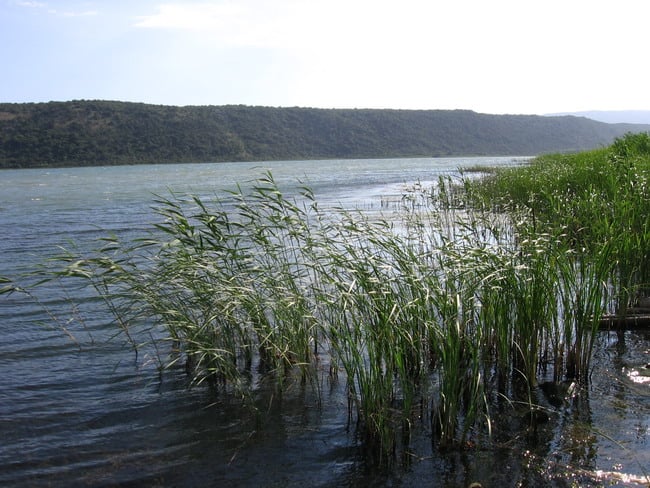
Lake Šas and reeds along its shore
The reed-fringed edge of Lake Šas

The local drive from the archaeological approach to Shasi restaurant is about three kilometres. Allow around 15 minutes. The prepared directions end at the restaurant access on the northeastern side of Lake Šas.

Access to this part of the shore passes through the restaurant grounds. Ask the host which waterside areas are accessible, as changing water levels and reeds can restrict access and views. Allow about 45 minutes to go down towards the shore and return. Continue the break with lunch at the restaurant, for which the plan leaves an hour and 15 minutes.

Marshy ground and dense reeds interrupt passage along the lake, so this stop does not include a circular lakeside walk. After lunch, return to the car and continue towards Štegvaš.

About: Lake ŠasNavigation route
03

Climb to Štegvaš for the lake panorama

45 min drive · 30 min for the viewpoint and approach

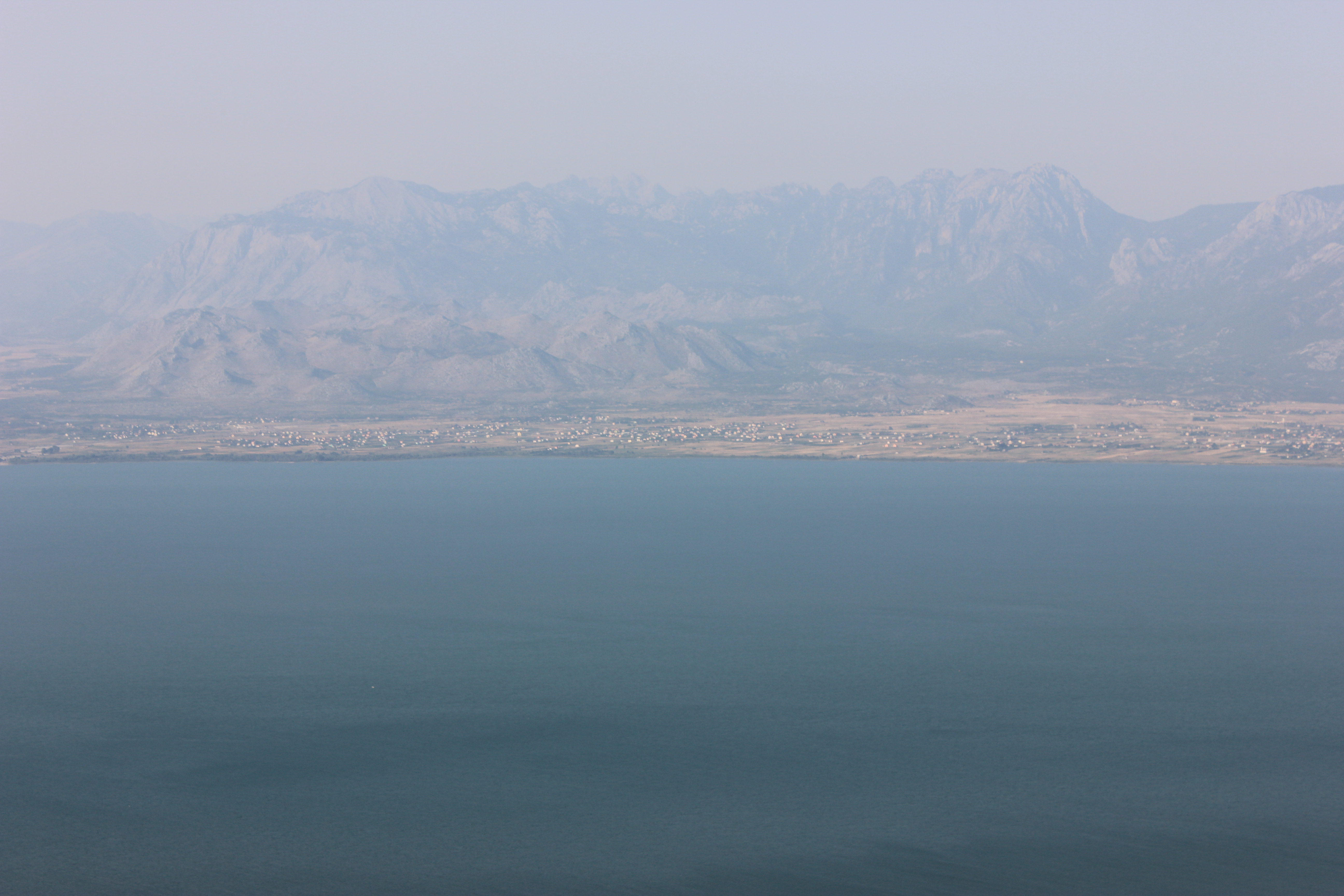
View from Štegvaš over Lake Skadar towards the Albanian mountains
Lake Skadar from the Štegvaš pass

From Shasi, drive back towards Vladimir, then take the road towards Ostros and the Štegvaš pass. Allow about 45 minutes for the roughly 17-kilometre leg. The prepared directions end at the pass, before the road continues towards the villages along Lake Skadar.

The ascent is paved, with bends and stretches without a centre line. Stop in the space beside the viewpoint, keeping the carriageway clear. The view and a place for a short pause are close to the pass itself. The half-hour stop includes getting out of the car, the short approach and time to enjoy the panorama.

The water you see here is Lake Skadar. Lake Šas, visited before the climb, lies on the other side of the hills.

About: ŠtegvašNavigation route
04

Return from the lake country to Ulcinj

1 hr drive

From the pass, retrace the ascent towards Vladimir and follow the prepared return leg to Ulcinj. Allow about an hour for the roughly 32 kilometres.

The full programme takes approximately seven to eight hours. This includes all visits, the walk to the churches and back, time beside the lake, lunch and a single half-hour buffer for slower driving or a longer stop.

Guide: UlcinjNavigation route

Trip highlights

01

Šas / Svač: the episcopal town above the lake

Svač was an episcopal centre on the route between Ulcinj and Shkodër, with a fort on the ridge and a settlement spreading below it. Its own bronze coinage, the follaro, provides evidence of its standing: surviving examples show St John and the town’s fortifications. The name Šas also refers to the nearby village, while Svač is often used to distinguish the archaeological town above the lake.

You can still recognise the fortified centre and the lower settlement as you explore. St Mary’s stands outside the walls on a broader plateau, while St John’s belongs to the upper, defended part. The remains of the gateway and walls show how the settlement used the ridge for protection and control of the surrounding ground.

St Mary’s retains tall walls, window openings and a decorated lintel. Gothic window forms appear alongside Romanesque elements, allowing details of the construction to be recognised even in the ruined building. Much of the church was damaged in the 1979 earthquake. Its interior is now open to the sky.

St John the Baptist was built in 1300 on the remains of an earlier church and against the defensive wall. Here the church, fortifications and ridge-top view come together: beside the former town centre, Lake Šas opens into view, with Briska Gora on the opposite side.

A local tradition associates Svač with 365 churches, one for each day of the year. The visit takes in the remains of far fewer buildings. St Mary’s and St John’s are the most conspicuous landmarks, while scattered wall fragments show how the settlement extended beyond them.

02

Lake Šas: reeds, open water and the shore at Shasi

Lake Šas lies between the hill of Svač and Briska Gora and is linked to the Bojana River by a channel. Water also comes from submerged springs, including Begovo Oko, the lake’s deepest part. Seasonal changes in water level alter the balance between open water, reeds and shoreline.

From Svač, the shape of the lake is easy to see. At the water’s edge, its marshy margin becomes more apparent. Reeds and sedges form a dense belt between the land and open water. They provide habitat and shelter for wildlife, while also making an uninterrupted walk around the shore impractical.

Shasi is a lakeside restaurant that grew out of a family property beside the water. It is associated with lake fish and food from the surrounding area. Its food offering developed through purchases from neighbouring households, linking it to the produce of the Ulcinj hinterland.

03

Štegvaš: the view from the pass over Lake Skadar

At Štegvaš, the road crosses the hills above the Ulcinj hinterland and reveals Lake Skadar. The water lies well below the pass, with the Albanian mountains beyond. This elevated position reveals several layers of the landscape: the lake, inhabited slopes and the high mountain rim behind them.

The pass forms part of the scenic road linking Ulcinj and the villages of Krajina with Virpazar. Driving that whole connection requires a long, careful journey along the narrow lakeside road. This outing uses only the approach from Vladimir to the viewpoint, then returns the same way towards Vladimir and Ulcinj.

The name Štegvaš also appears beside another view on the Ulcinj-facing side of the hills, towards the Anamalit plain and Bojana. These are different places. The prepared navigation points to the pass itself and the panorama of Lake Skadar.

Driving directions from Ulcinj · 1/2
Driving directions from Ulcinj · 2/2
12 min read
1day

Budva, Miločer and Sveti Stefan by car from Tivat

From Praskvica Monastery and the royal park to the shore at Sveti Stefan. After lunch come Mogren, Budva’s streets, the museum, Citadel and town walls.
Explore this tripDriving directions from Ulcinj · 1/2Driving directions from Ulcinj · 2/212 min read
1day

Stari Bar and the Old Olive Tree by car from Budva

The Old Olive Tree at Mirovica, the archaeological town below Rumija and lunch on Stari Bar’s market street. A trip along the coastal road, with time to explore and prepared navigation.
Explore this tripDriving directions from Ulcinj10 min read
1day

Ostrog by car from Podgorica: monastery visits

Visit Zdrebaonik on the way from Podgorica, explore Upper and Lower Ostrog, then have lunch on the Sokoline terrace overlooking the monastery.
Explore this tripDriving directions from Ulcinj · 1/2Driving directions from Ulcinj · 2/211 min read
Explore all drives and day trips from UlcinjView car hire deals
Airports
Getting to Ulcinj via Podgorica, Tivat or Tirana, with transport from the airport to town.
ParkingWhere to park in Ulcinj and how prices and charging hours change with the season.
Practical informationGetting between Ulcinj's centre and Velika Plaza, with mobile services for your stay.
SafetySpending time safely on Ulcinj's beaches and knowing who to contact in an emergency.
Explore the city
Stay plansItineraries for 1-10 days with Ulcinj Old Town, Velika Plaza, Ada Bojana and Lake Skadar.
Find a rental carUlcinj city guide
Bar

Bar

Open guide
Petrovac

Petrovac

Open guide
Budva

Budva

Open guide
Cetinje

Cetinje

Open guide
Podgorica

Podgorica

Open guide
Kotor

Kotor

Open guide
Tivat

Tivat

Open guide
Herceg Novi

Herceg Novi

Open guide
Igalo

Igalo

Open guide
Zabljak

Zabljak

Open guide