
Hire And Travel
  • List your vehicles
  • Home
  1. Home
  2. Montenegro
  3. Podgorica
  4. Guide
  5. Drives and day trips
  6. Lakes and Katuns of the Kucke Mountains from Podgorica
logo
Home
About us
Terms of use
Privacy policy
List your vehicles
Become our partner
Contact us
FAQ - Questions and answers
Brands We Trust
Hire And Travel - 2026. All rights reserved.
Day trip by car from Podgorica

Lakes and Katuns of the Kucke Mountains from Podgorica

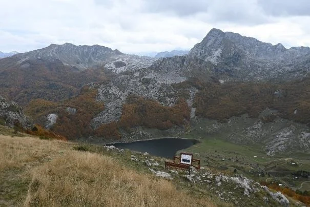
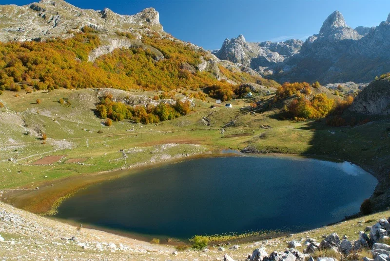
The jagged peak of Pasjak rises above Lake Bukumirsko, while the grassy shore looks out toward the rocky summits of the Kucke Mountains. Beyond the Sirokar pass lies another lake basin: Lake Rikavacko below Vila, beside the mountain ridge toward Albania. On this trip, you reach Bukumirsko and Mokra by car, then continue on foot through the katun landscape to a view of Rikavacko.
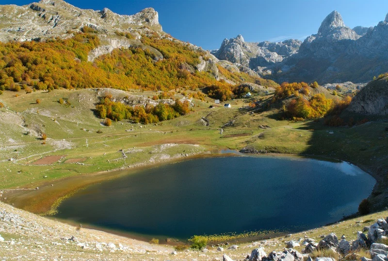
Lake Bukumirsko with grassy shores and rocky peaks of the Kucke Mountains

Trip overview

Trip duration
About 11 to 12 hours
Number of stops
4
Route length
About 110 km
AuthorHire And Travel Editorial TeamLast updatedOctober 5, 2026

The guide was prepared through research into the route and the attractions visited. The content was reviewed, confirmed and verified by Takumi Bulatovic, October 5, 2026.

Why set aside a day for this trip

Set aside a day for this trip if you want to experience Montenegro's high mountains without making a summit climb the focus. A lakeshore you can reach by car gives you time beside the water, while the walk across the pass reveals how pastures and katun settlements sit among the rocky ridges. You do not have to climb a two-thousand-meter peak to understand this landscape: the view into the second lake basin comes after a gradual ascent from Mokra. This is still more than a trip with a few brief stops outside the car. You get the most from it if you can walk about 8.6 km to the viewpoint and back, as well as taking a shorter walk near Lake Bukumirsko.

Trip and costs at a glance

Trip durationAbout 11 to 12 hours
TransportA car is required · rental offers
Sights on this trip
  • Lake Bukumirsko
  • Mokra
  • Sirokar
  • view of Rikavacko
Fuel consumptionEstimated about 9 to 12 l
TollsNo cost
Admission costsNo cost
NavigationOpen the complete route for navigation

Map and navigation

Drive to Bukumirsko Lake and Mokra. Širokar and Drekalov Viewpoint are visited on foot, as described in the stages.

Open the complete driving route or the leg you need.

Complete route: departure, stops and return↗Podgorica → Ubli → Bukumirsko Lake parking↗Bukumirsko Lake → Mokra↗Mokra → Ubli → Podgorica↗Google Maps may limit the number of waypoints on a phone. If a stop is missing, use the individual legs below the complete route.

Route, visits and breaks

Timings are approximate. The trip includes time beside Lake Bukumirsko, the full walk back from Drekalov Vidik to Mokra, lunch and a buffer.

01

Setting out through Kuci to Lake Bukumirsko

1 h 45 min driving · 15 min for parking and access

Leave Podgorica in the morning, traveling through Ubli, Krzanja and Kastrat. Open the prepared navigation route. It takes you through Ubli to the paved approach at Mokra and back the same way. The walking section toward Sirokar is not a driving waypoint. For the first visit, open the parking location at Lake Bukumirsko separately, then continue to Mokra after visiting the lake.

Allow about an hour and 45 minutes to drive to the lake, plus another 15 minutes for parking and reaching the shore. The road through Kuci is paved, but it has narrow bends and climbs into the mountains, so driving speeds in the city are not a useful basis for estimating the journey. The final kilometer of the approach to Bukumirsko was paved in 2025. Leave the car in the parking area above the lake rather than driving down to the water's edge.

About: Lake BukumirskoNavigation route

Questions before visiting the Kucke Mountains

Is an SUV enough to drive to Lake Rikavacko?

The SUV label alone does not establish that a vehicle has the ground clearance and drivetrain needed for mountain gravel roads. The official guide already recommends an off-road vehicle for the section from Mokra to Sirokar. This does not confirm that every rental SUV can continue to the shore of Rikavacko. This itinerary uses the paved approach to Mokra and a walk to the viewpoint. If you are considering off-road driving, you need a separate check of the entire road and permission to use your rental vehicle in those conditions.

Can this itinerary be planned for spring or late fall?

Choose snow-free days for the full itinerary, primarily from June through September. Mokra is at about 1,500 m and Sirokar above 1,700 m, so a passable approach to the lake does not mean the higher walking section is also free of snow. Outside the summer season, check road and trail conditions with the management of Komovi Nature Park. Shorter daylight hours further limit this 11-to-12-hour trip. The temperature in Podgorica is not a reliable indicator of conditions on the pass.

Can the lakes be added to the Circuit around Korita on the same day?

Set aside another day for the Circuit around Korita and Grlo Sokolovo. That trip has its own driving circuit and walking trail, while the walk from Mokra to Drekalov Vidik and back on this trip alone covers about 8.6 km. Places being close on a map does not mean there is a short paved connection: the approach to Rikavacko from Korita becomes a gravel road. Combining the trips would leave too little time for both visits.

Full-day trips

More day trips from Podgorica

1day

Biogradska Gora by car from Podgorica, lake and old-growth forest

Visit Morača Monastery and walk the full circuit around Biogradsko Lake through old-growth forest. A day trip by car from Podgorica with lunch in Kolašin, costs and a highway return.
Explore this trip9 min read
1day

Cetinje and Lovcen by car from Podgorica, with a cable car ride

Visit the royal palace in Cetinje and Njegos's Mausoleum, then take a cable car ride from Kuk. A full day out with lunch, costs and a prepared route for navigation.
Explore this trip
Guides for your stay in Podgorica

Open a dedicated Podgorica guide for arrival, accommodation, food, sights or practical questions during your stay.

Planning your stayPodgorica guideOpen the city overview when you are planning arrival, accommodation, meals, sightseeing and everyday needs in Podgorica.
Open guide
About the cityHow Podgorica grew from an Ottoman town into the capital, and what remains of its past.Things to doWhat you can do independently in Podgorica and which activities need a booking or ticket.SightsThe significance of Podgorica's sights, from the Ottoman clock tower to Svetlana Kana Radevic's architecture.Lesser-known placesLesser-known places in Podgorica, such as the bookshop beneath the dome of a former hammam.With childrenPlaygrounds, woodland walks, movies, children's theater and a water park, plus trips to the donkey farm, lake and waterfall.FoodThe origins of Podgorica's dishes distinguish city specialties from wider Montenegrin cooking.Where to eatPlaces for a meal or coffee in Podgorica, with recommendations on what to order.Where to stayRecommended accommodation in Podgorica, where it is and what it offers guests.
Find a car for your trip to the Kucke MountainsCompare car rental offers in Podgorica. A passenger car takes you to Lake Bukumirsko and Mokra, where the walk toward Sirokar begins.
View car rental deals
More places to plan

Guides to other places in Montenegro

Drives and day trips from nearby destinations

Cetinje - drives and day tripsPetrovac - drives and day tripsBudva - drives and day tripsKotor - drives and day tripsBar - drives and day tripsTivat - drives and day tripsUlcinj - drives and day tripsHerceg Novi - drives and day tripsIgalo - drives and day tripsZabljak - drives and day trips
Travel across MontenegroContinue with the Montenegro guide

Use the Montenegro guide to see how the coast, Lake Skadar or the north fits the number of days you have, with realistic travel times and suitable transport.
Open the Montenegro guideView car rental deals in Montenegro
02

Lake Bukumirsko and the view above the shore

1 h 15 min by the lake · 45 min for the viewpoint and return

Bukumirsko Lake and the surrounding peaks

Allow about an hour and 15 minutes beside the lake. Walk from the parking area to the grassy shore and spend time on the accessible dry ground, where the peaks above the lake are visible just across the water. There are established rest areas and information boards beside the lake. Wetland vegetation covers part of the shore, so this itinerary does not assume you can walk continuously around the entire water's edge.

Then follow the marked trail to the Bukumirski Pogled viewpoint. It is about 500 m from the lake, or roughly 15 minutes on foot. The walk out, time at the viewpoint and return are allocated 45 minutes in total. From above, the relationship between the lake, the grassy basin and the rocky slopes is clearer, giving this short walk a different perspective from the time spent on the shore.

About: Lake BukumirskoNavigation route
03

A short drive to Mokra and a lunch break

15 min driving · 15 min for parking · 1 h for lunch and rest

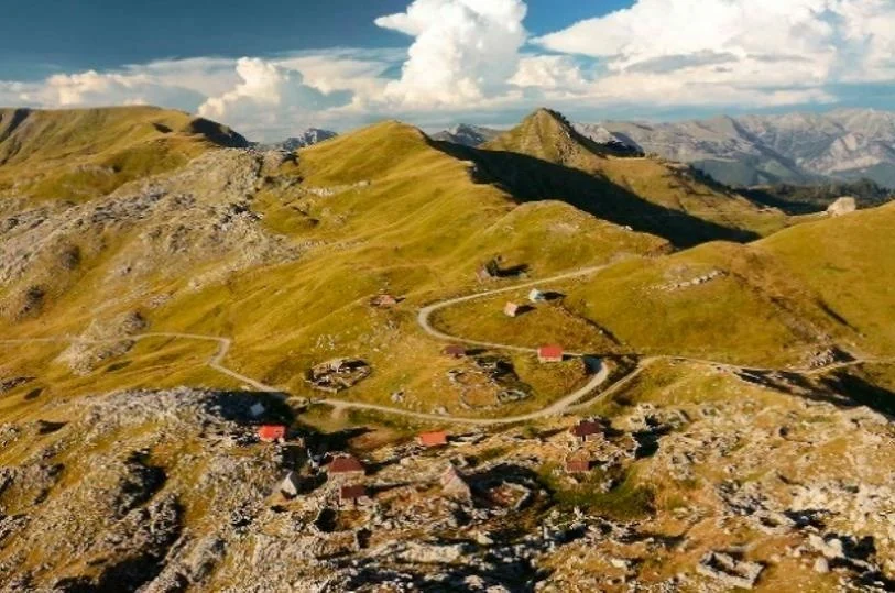
Mokra katun and the mountain valley

It is approximately four kilometers from Lake Bukumirsko to Mokra. Allow about 15 minutes for the drive. Return to the paved road and follow the prepared route to the starting point toward Sirokar. A gravel road branches off here, while the car stays by the paved approach for this trip. Use an available widened area that does not block access, allowing about 15 minutes for parking and getting ready to walk.

The itinerary includes an hour at Mokra for lunch and a rest before the climb. Bring a meal from Podgorica for this schedule: the trip does not depend on a household serving food that day. Katun Mokra's services can be arranged separately in advance, but a booked lunch or organized activity is not included.

About: MokraNavigation route
04

Walking from Mokra to the katun at Sirokar

1 h 10 min walking · 25 min at the katun

Širokar Ljakovića katun

From the paved approach at Mokra, follow the marked route toward Sirokar. The gravel section is about 3.8 km long, with approximately an hour and ten minutes allowed for the walk uphill. The official guide recommends an off-road vehicle for driving this section. The passenger car therefore stays at Mokra, and this stage is covered on foot.

At Sirokar, at about 1,760 m, spend approximately 25 minutes near the Ljakovica katun. Look at the arrangement of the katun houses and the pastures around the pass, then rest before the short continuation to the viewpoint. Visiting the katun landscape does not include entering a household, being served refreshments or meeting livestock herders. Their presence depends on the season and their work in the mountains.

About: SirokarNavigation route
05

Drekalov Vidik and the walk back to Mokra

15 min walking · 25 min for the view · 1 h 20 min walking back

Rikavačko Lake from Drekalov Viewpoint

It is another 500 m or so from Sirokar to Drekalov Vidik, approximately 15 minutes on foot. Allow about 25 minutes at the viewpoint to look out over Lake Rikavacko, Vila and the ridge toward Albania. You view the lake from above: descending to its shore is not part of this itinerary, and it should not be entered as a driving destination.

Return the same way through Sirokar to the car at Mokra. The walk back is about 4.3 km, with approximately an hour and 20 minutes allowed. The full walk to the viewpoint and back is about 8.6 km, taking around three hours and 35 minutes including time at the katun and viewpoint. This is a separate mountain portion of the day that requires a passable, snow-free route and good visibility, beyond simply being able to drive to the lake.

About: Lake RikavackoNavigation route
06

Returning through Kuci to Podgorica

1 h 45 min driving

From Mokra, return to Podgorica along the paved road through Kastrat, Krzanja and Ubli. The prepared navigation route keeps Ubli as a waypoint on the return, so it does not send you along a different mountain approach. Allow approximately an hour and 45 minutes for the drive. This route does not use the highway and has no tolls.

The full driving route, including the visit to the lake and the continuation to Mokra, is approximately 110 km. Plan for about 11 to 12 hours for the trip, including visits, walking, lunch, parking and a buffer. The calculation includes a 45-minute buffer for slower driving or longer stops. Leaving early enough in the morning gives you time to finish the mountain walk in daylight.

Guide: PodgoricaNavigation route

Trip highlights

01

Lake Bukumirsko, Pasjak and traces of glaciers

Lake Bukumirsko lies in the Kuci region, at the foot of Zijovo, approximately 1,450 m above sea level. Jagged rocky peaks rise above its grassy basin, with Pasjak standing out among them. Because these slopes are so close, the lake offers more than a place to rest beside the water: from the shore, you can see how the high mountains rise from an almost level meadow.

The lake basin was shaped by glaciers. Today, it receives water from precipitation and melting snow. It is approximately 210 m long and 130 m wide, with a depth reaching almost 17 m. That relationship between surface area and depth explains why the calm, seemingly shallow scene along the grassy edge tells you little about the lake as a whole. Wetland vegetation occupies part of the shore, while the rocky slopes remain open above it.

At the Bukumirski Pogled viewpoint, the landforms around the water also deserve attention. Beside the lake is a moraine, a deposit of rocks and other material left behind by a glacier. From higher ground, it is easier to connect that deposit with the basin and surrounding peaks than it is from the shore. The view therefore offers a geological explanation as well as a photograph of the lake.

The name is associated with the Bukumiri and legends about their disappearance. One story tells of a blood feud, another of a water creature and red-hot stones thrown into the lake. These are local legends, rather than a confirmed history of a community's disappearance. Their value lies in showing how long this lake has held a place in the stories of the Kuci region.

02

Mokra, meadows and summer life in the mountains

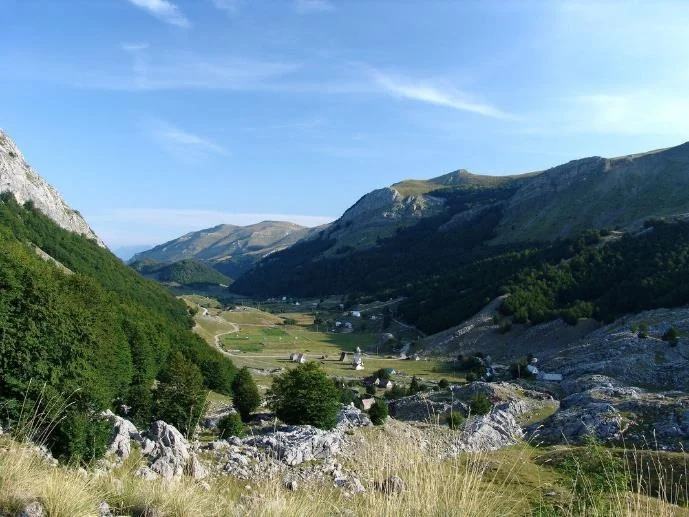
Mokra is a mountain area at about 1,500 m, between Lakes Bukumirsko and Rikavacko. Meadows, woodland edges and katun houses occupy gentler ground among higher ridges. From the paved approach, you enter a landscape where roads mainly connect pastures and seasonal settlements, which also explains the change in road surface toward Sirokar.

A katun is a settlement associated with spending the summer with livestock on mountain pastures. Its houses and other buildings serve people who use grazing land at higher elevations during the warmer part of the year, rather than keeping their livestock only beside the permanent settlement. The meadows between the houses are therefore not simply empty space: they are part of how the mountains are used. Alongside this way of life, Mokra now also offers stays for guests. The Podgorica Tourism Organization presents Katun Mokra through accommodation and activities arranged in advance, such as horseback riding, showing how an area once used mainly for livestock farming is opening to visitors.

03

Sirokar and the Ljakovica katun

Sirokar is a pass on the route from Mokra toward the Rikavacko basin, with the Ljakovica katun at about 1,760 m. Sources also use the name Lakovica, so both names refer to the same katun. The houses are grouped on gentler ground below higher rocky slopes, beside the pastures that give people a reason to stay here seasonally.

The move by livestock herders and their animals to a katun is called izdig. In Kuci, use of the mountains has traditionally been associated with komunica, common pasture and woodland. Individual clans had the right to establish a katun in a particular place, while the surrounding grazing land remained shared. This explains why katuns have family names, while their pastures cannot be understood as a simple extension of each house's yard.

The traditional dwelling used by shepherds was called a glada and was built of stone. Beside it were mljekare for storing cheese and clotted cream (skorup), often partly sunk into the ground to keep them cool, and torine for holding livestock overnight. Different buildings had different purposes: living space, food storage and sheltering the herd. Understanding these functions helps you see the settlement as a place of work and everyday life, rather than a few isolated houses at a viewpoint.

04

Lake Rikavacko from Drekalov Vidik

Lake Rikavacko lies in a basin below Vila, beside the mountain ridge toward the border with Albania. The lake itself is at approximately 1,310 m, while Vila reaches 2,093 m. From Drekalov Vidik, that difference in elevation becomes clear: the water lies well below the pass, with slopes rising above it to enclose the valley. This is why the view from higher ground offers a different understanding of the landscape from a visit to the shore.

The lake is glacial in origin and elongated, approximately 525 m long and 235 m wide. It receives water from the Rikavac stream and precipitation, and water also drains underground toward the Cijevna and Ribnica catchments. The absence of a large visible outlet therefore does not mean the water stays trapped in the basin. In the karst terrain, part of its course takes place below the surface, linking this high lake with rivers much farther down in Podgorica's hinterland.

10 min read
1day

Krug oko Korita from Podgorica, Medun and Grlo Sokolovo

Drive the Krug oko Korita from Podgorica, with Medun and the Marko Miljanov Museum, a loop walk to Grlo Sokolovo and views from Delaj. Trip duration, costs and navigation.
Explore this trip9 min read
1day

Lake Skadar by car from Podgorica, viewpoint and boat trip

From Pavlova strana and Danilo's Bridge to a boat trip from Virpazar. A day trip by car from Podgorica with time for the lake, lunch and the drive back.
Explore this trip10 min read
1day

Ostrog by car from Podgorica: monastery visits

Visit Zdrebaonik on the way from Podgorica, explore Upper and Lower Ostrog, then have lunch on the Sokoline terrace overlooking the monastery.
Explore this trip11 min read
Explore all drives and day trips from PodgoricaView car rental deals
Airports
Getting to the city from Podgorica or Tivat Airport.
ParkingWhere to park in Podgorica for a short or longer stay, and how to pay.
Practical informationUsing city transport and a tourist SIM card during your stay in Podgorica.
SafetyVisiting Podgorica safely and knowing who to contact for help in an emergency.
Explore the city
Drives and day tripsDay trips by car from Podgorica to monasteries, lakes and mountain viewpoints, with stops, costs and prepared navigation.
Stay plansItineraries for 1-10 days with Stara Varos, the Moraca, Gorica, Duklja and Lake Skadar.
Cetinje

Cetinje

Open guide
Petrovac

Petrovac

Open guide
Budva

Budva

Open guide
Kotor

Kotor

Open guide
Bar

Bar

Open guide
Tivat

Tivat

Open guide
Ulcinj

Ulcinj

Open guide
Herceg Novi

Herceg Novi

Open guide
Igalo

Igalo

Open guide
Zabljak

Zabljak

Open guide
Find a rental carPodgorica city guide