
01Location and climate
The high plateau, mountain massif and changing seasons.
Location and climate
The high plateau, mountain massif and changing seasons.
Jezerska Povrs and the mountain climate
Zabljak lies in the north-western part of Jezerska Povrs, along the north-eastern side of the Durmitor massif. This high plateau has settlements, meadows and forests, with mountain peaks rising above it. The town occupies only part of this much wider landscape. The Tara River flows through a deep canyon below the plateau.
Long, cold winters with snow and short, cool summers characterise Zabljak's climate. Its altitude explains why it is cooler here than in coastal towns. Weather conditions in the higher parts of Durmitor also differ from those in the town itself.
02Names and the settlement's development
Earlier names, the role of trade and the town's reconstruction.
Names and the settlement's development
Earlier names, the role of trade and the town's reconstruction.
Varezina Voda, Hanovi and the name Zabljak
Varezina Voda is mentioned among the settlement's earlier names. Later it was known as Hanovi, a name taken from the inns for travellers and caravans. The settlement served as a resting place on routes through the Durmitor area before developing a broader role in trade and administration.
The settlement took the name Zabljak in 1870. The date marks a change of name. The settlement already existed. The Durmitor town should be distinguished from Zabljak Crnojevica, a historic fortified town in the Lake Skadar area. Their histories belong to different parts of Montenegro.
Trade, post-war reconstruction and tourism
Trade, crafts and hospitality developed in Zabljak during the final decades of the 19th century. The town was becoming an administrative centre for the Durmitor area. Between the two world wars, the mountains began attracting the first tourists, while transport links with Niksic via Savnik, and with Pljevlja, made arrival easier.
The settlement was severely damaged during the Second World War. Post-war reconstruction and the later growth of tourism changed its appearance and economy: hotels and other accommodation were built alongside other town buildings and public institutions.
03Urban space and architecture
The centre, Pitomine and regional architectural heritage.
Urban space and architecture
The centre, Pitomine and regional architectural heritage.
The centre and the outskirts towards Pitomine
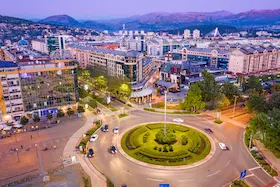
Trg durmitorskih ratnika, the town square, is one of the reference points in the centre. Hotels and public institutions line the town's streets, including the Public Library on Bozidara Zugica Street. The bus station is another important town landmark, particularly for visitors arriving by public transport.
Development becomes more spread out towards Pitomine. Detached houses and holiday homes stand alongside meadows and patches of coniferous woodland. Pitomine forms the edge of the town towards the Durmitor area, with houses spaced further apart than in the compact centre.
Steep roofs and architectural heritage
In traditional construction in the Durmitor area, the living part of a house was often built of wood above a stone basement. The lower level was used to store produce or house livestock. Steep roofs were covered with wooden boards or shingles, and separate buildings for livestock and storing milk were built beside the houses.
Katuni are summer settlements for livestock herders beside mountain pastures. People stayed there while their animals grazed on the summer pasture. This rural building tradition belongs to the wider Durmitor area. In today's Zabljak, larger hotel and public buildings stand alongside family homes.
04Public role and culture
Municipal functions, the ecological declaration and cultural institutions.
Public role and culture
Municipal functions, the ecological declaration and cultural institutions.
A municipal centre beside a protected area
Zabljak is the municipal centre of the Durmitor area, but on 20 September 1991 it was also the setting for an important national decision. An open-air session of Parliament held in the town adopted the Declaration on Montenegro as an Ecological State. The event linked Zabljak to Montenegro's modern political history and its officially expressed commitment to preserving nature.
The library and cultural gatherings
The Public Library is part of Zabljak Culture Centre. It is on Bozidara Zugica Street and belongs to the COBISS system, which allows users to search library collections.
The Culture Centre also organises Dani durmitorske zdrave hrane, the Days of Durmitor Healthy Food event. It presents products and dishes from the area, including dairy products and skorup, a traditional cream made from milk. This gathering connects the town's cultural space with the livestock-farming and agricultural heritage of the surrounding villages.
05Zabljak and its landscape
Brief context for the lake and the cultural heritage of the surrounding plateau.
Zabljak and its landscape
Brief context for the lake and the cultural heritage of the surrounding plateau.
The lake and medieval tombstones around the town
Crno Jezero, or Black Lake, lies outside the compact town centre, in woodland beneath Medjed. Nearby Novakovici has cemeteries of stecak tombstones, medieval grave markers. The lake provides a sense of Zabljak's natural surroundings, while the cemeteries reveal the plateau's earlier history. Individual places are covered in the guide to attractions in Zabljak.
For meal options, continue to the recommendations on where to eat in Zabljak, and compare accommodation locations in the guide to where to stay in Zabljak.
Centre, outskirts and park
Trg durmitorskih ratnika, town streets and public institutions.
The town's edge towards the Durmitor area, with detached houses and open land.
The lake and mountain landscape outside the compact town centre.